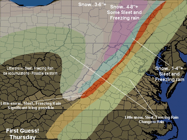
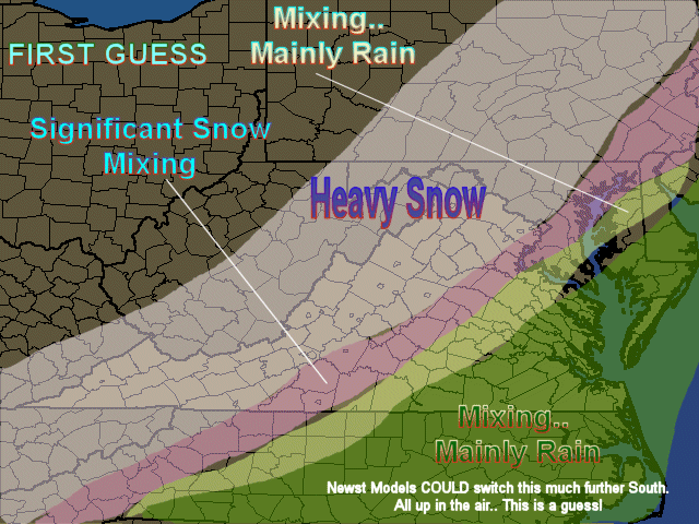
Tuesday, December 13, 2005

12/15 First Call


What?
Significant Icing event. Moderate Icing event and Light Icing event
Some Accumulating Snows

Where?
Significant Icing: Immediate Piedmont: Maryland, Virginia, North Carolina
Major Icing: Immediate Piedmont to 35 miles west of I-95; Maryland, Virginia
North Carolina : West Central NC
Light Icing: I-95 to about 35 miles west of I-95: West Central NC
Snows: Higher elevations of Northern Virginia and Western Maryland. A large Part of Pennsylvania, West 40 miles west of I-95

When? Starting Thursday Early Morning South overspreading northern areas by Late Morning

Comments: Tough call in many ways. A lot of precip will fall over very shallow cold air. The Warm air appears to truly Surge over the area and warm areas close to or above freezing. There is a chance for significant rains as well. If things stay frozen, ice storm conditions could be reached by a lot more areas than what I am indicating on my first guess map. May issue a follow up call tomorrow night.. but my guess may be all the time I have to do.

http://mawinterweather.blogspot.com

Of Note: Large potential Snow Storm early next week!

Friday, December 09, 2005

12/8 - 12/9 Post Mortem

Not as bad off as last storm locally... expanded areas i definitely got wrong..
 
Predicted: Charlottesville: 3-5" - Sleet
Actual: 1-2" Big bust!
Predicted: Roanoke: 1-3" Icing concerns. May reach Ice Storm criteria
Actual: See a report of .25" of ice and .75 inches of sleet. no snow.. Ice correct
Predicted: Lynchburg 1"  Icing concerns. May reach Ice Storm criteria
Actuals: No snow. .20 of ice mainly trees
Predicted: Richmond: Rain
Actual: Rain
Predicted: Fredericksburg: 2-4" Snow.. then Sleet and Freezing Rain
Actual: .8" Way off!
DC National: 2-4" Snow.. then Sleet and Freezing Rain
Actual: 1.6" .. busted.. but could have been worse!
Predicted: Baltimore: 3-5" Snow.. then Sleet and Freezing Rain
Actual: 3-4" range.. not too bad
Predicted: Dulles: 3-5" - Sleet a real possibility.
Actual: 2.0" Bad.. but not horrible
Predicted: Hagerstown: 4-8" (maybe 10")
Actual: 4-6" No 10" though. Not too bad
Predicted: Purcellville: 4-8"
Actual: 3-4" A miss
 
So in general.. over predicted.. Odd scenarios last night as the models came in colder, but ice still occurred and in more regions and sooner than thought.
 
Good analyses of the storm last evening provided by the first Met on the board! A friend and old coworker!


Thursday, December 08, 2005

12/8 - 12/9 Final Call


Charlottesville: 3-5" - Sleet a real possibility. Starting 8-10pm Roanoke: 1-3" Icing concerns. May reach Ice Storm criteria Lynchburg 1" Icing concerns. May reach Ice Storm criteria Richmond: Rain
Fredericksburg: 2-4" Snow.. then Sleet and Freezing Rain Starting 8-11pmDC National: 2-4" Snow.. then Sleet and Freezing Rain Starting 8-11pmBaltimore: 3-5" Snow.. then Sleet and Freezing Rain Starting 9-Midnight
Dulles: 3-5" - Sleet a real possibility. 8-11pm
Hagerstown: 4-8" (maybe 10") Starting 8-11pm Purcellville: 4-8" Starting 8-11pm

Please note.. this is a dynamic system.. it could compensate for some warmth that it is en-training off the ocean and cause places to shift between snow and sleet and freezing rain. If we get Thunderstorms( a possibility) we will see higher totals of precip in whatever type is falling on you! That could be interesting!

Wednesday, December 07, 2005

12/8 - 12/9 First GUESS!

Quick hitting snowstorm will commence in the region later tomorrow through noon Friday. Southern 1/3rd of the region should see a mix to sleet and freezing rain and then rain. Norther 2/3rds a General 3-6" but chances for 2 things.. A dry slotting during energy transfers and a chance for thundersnow or convective banding which could either lessen ior intensify snow amounts..

Much to watch.. Take this as aGuess! That is all it is!

Tuesday, December 06, 2005

12/5 - 12/6 Storm Post Mortem

12/5/2005 Storm Post mortem:
 
Yes, I busted: Some totals came closer than it appeared.. My list and actuals:
 
Charlottesville: 5-10" Starting 7-10am
Actual: 2.0” (Big Bust!)
 
Roanoke: 5-10"+ (Some spots 12") Starting 4-9am
Actual: maybe 2-3”
 
Lynchburg 4-8" Starting 4-9am
Actual: maybe 2-3”
 
Richmond: 3-6" (Lots of Mixing with rain)  Starting 9am - noon
Actual: Not bad: 3-6” seems pretty good
 
Fredericksburg: 5-10" Starting 10am to 1pm
Actual: Not bad: Maybe 4-6”
 
DC National: 5-10" Starting 11am - 1pm
Actual: 2-4”
 
Baltimore: 5-10" Startng 11am - 2pm
Actual: 2-4” (bad)
 
IAD: 5-10" Starting 11am-1pm
Actual: 2-4” (Bad)
 
Hagerstown: 4-8" Starting 11am-1pm
Actual: 1-3” (Bad)
 
Purcellville: 4-8" Starting 11-1pm
Actual: 1-3” (Bad)
 
Overall: Bad bust! Would be an F If I were graded!
 
What I learned:
  1. Do not go against ALL models unless the reality of radars and the situation is unfolding (Like January 2005)
  2. Eastward shift seems to bean issue this year… eastward and shearing
  3. Shave some of the snow totals by 1-3” in general when looking at one of the trusted models.
 
I will use this in my next predictions which will start Tomorrow NIGHT


Yahoo! Personals
Single? There's someone we'd like you to meet.
Lots of someones, actually. Try Yahoo! Personals

Sunday, December 04, 2005

12/5 - 12/6 Final Call


This really Bucks the Models! Serious bust potential here!


This still looks pretty good, but start times!

Charlottesville: 5-10" Starting 7-10am

Roanoke: 5-10"+ (Some spots 12") Starting 4-9am

Lynchburg 4-8" Starting 4-9am

Richmond: 3-6" (Lots of Mixing with rain) Starting 9am - noon

Fredericksburg: 5-10" Starting 10am to 1pm

DC National: 5-10" Starting 11am - 1pm

Baltimore: 5-10" Startng 11am - 2pm

IAD: 5-10" Starting 11am-1pm

Hagerstown: 4-8" Starting 11am-1pm

Purcellville: 4-8" Starting 11-1pm

Few things on this:

1. Think Storm will be further west than models

2. See good Wrap around/deformation zone possible

3. Expecting a closer to the coast pull ultimately

12/5 - 12/6 First CALL

Ok. This is my first call, likely final call after next Model runs.Giving some Locations and amounts!
Charlottesville: 5-10" Starting Early Afternoon
Roanoke: 5-10"+ (Some spots 12") Starting 7-9am
Lynchburg 4-8" Starting 7-9am
Richmond: 3-6" Starting 9am - noon
Fredericksburg: 5-10" Starting noon to 3pm
DC National: 5-10" Starting 3-6pm
Baltimore: 5-10" Startng 5-8pm
IAD: 5-10" Starting 3-6pm
Hagerstown: 4-8" Starting 3-6pm
Purcellville: 4-8" Starting 3-6pm

Few things on this:
1. Think Storm will be further west
2. See good Wrap around/deformation zone possible
3. Expecting a closer to the coast pull ultimately

Saturday, December 03, 2005

Second Guess Dec 5th/6th event!


I am betting on a pretty big blockbuster here! Only concern would be track.. but I think plenty of dynamics get involved and push it high and precip far west!

Final call will be issued Tomorrow later afternoon or evening. Sorry, busy day will preclude sooner. May send updates if things change dramatically!

12/3 Winter Weather Alert! For TONIGHT's storm

 
Second storm looking like a classic I-95 Storm now!


Great School in Northern Virginia. http://www.ambleside.org


Yahoo! DSL Something to write home about. Just $16.99/mo. or less

Final Call 12/3 Event

I am concerned about the Valleys seeing an Ice Storm. Expect Winter Storm Warnings for some Far western Counties.

Storm for Monday is becoming a CLASSIC winter Storm.. I-95 cities could be very white. Will post updates on this later this evening!

Friday, December 02, 2005

First Guess! 12/5 Event


MAY REALLY SHIFT! Stand By!

First Real Snow Chances for the Region Monday. Appetizer tomorrow Night.

First Real Snow Chances for the Region Monday. Appetizer tomorrow Night.
 
What? 2 Systems will affect the region between Today and Tuesday with Winter weather
 
System 1: No big deal, but a burst of snow and sleet should occur tomorrow evening that should last until Midnight.
 
System 2: Significant chance of a real snowstorm.
 
Where?
System 1: Northern 2/3rds of Virginia and Western Maryland. The Snow should change to rain for most regions, but North Central Maryland and the Northwestern part of Virginia.
 
System 2: All regions could see some snow, but again, best chances appear to be northern 2/3rds of Virginia, and western 2/3rds of Maryland. Snow should overtake the region and then a mix to rain, very quickly southern regions, and slowly a creep northward and westward. Right now would call for I-95 areas north of Frederickburg to see a moderate event, while areas west of this by 15 to 20 miles will see a potentially major storm.
 
How Much?
System 1: Dusting most areas at best, but 1 to as much as 3 inches in the areas staying snow or a mix. Grassy and elevated surfaces only.
 
System 2: (First Guess here) Potential exists for the Moderate areas to see 3 to 5 inches and the Major areas (mainly snow) to see 5 to 10 inches with some 12 inch readings in the higher elevations and immediate piedmont areas of Northern Virginia (North of Charlottesville and  western Maryland).
 
When?
System 1: Saturday late day through Midnight for most regions, but the areas mentioned where accumulations could occur will be through Sunday Morning.
 
System 2: Sunday Night through Monday.. possibly stretching to early Tuesday morning.
 
Comments: System 1 will not be a big deal. System 2 seriously could be, but we are early in the game on this! Shifts in the track obviously mean chances for more or less snow. As models converge on the system, updates will come. Also of note, roads are warm so salt will do a good job on helping melt the snow.
 
Expect snow impact Maps possibly tonight or tomorrow morning.. First Guess on Accumulations afternoon or evening tomorrow.
 
All for Now!


Yahoo! Shopping
Find Great Deals on Gifts at Yahoo! Shopping