Friday, January 29, 2010

Snow expands north!

It is late in the game and at Night.

I have update http://www.midatlanticweather.com

It is late and I am sorry I do not have time to post all totals!

DC Area - 3 to 6" possible
Roanoke - 8 - 12"
Richmond - 10 - 14+
Norfolk 8 - 12"
Charlottesville - 6 - 10"
Fredericksburg - 4 - 8"
Raleigh - 6 - 8" - Sleet becoming a concern!
Asheville - 12"
Wintergreen - 10 - 14"
Harrisonburg - 8 - 10"

Biggest changes - more mix possible Central NC
Precip has advanced north.

North could see 1 - 3" more than I show if north trends continue.

Map posted at http://www.midatlanticweather.com

Good night!

Storm on track - Hostoric Winter and Snow Storm for Southern Third of VA and a lot of NC!

I would not stray too far from my map for Virginia that I have up on Mid Atlantic Weather. This looks like a Historic event. Snow will start in the evening in the southwest and overspread the southern third of Virginia and the northern half of North carolina. I may say a 1 to 3  inch increase in higher amount locations could occur as the ratios of snow per liquid equivalent will be high! That is rare for that part of the country. Snow will gradually progress north but it seems unlilkely it will make it past the southern DC metro area. Around that area an inch may fall. A very cold day with temps region wide in the 20s tomorrow. North Carolina, South Carolina and Northeast Georgia could see Ice totals up to or over 1 inch. Snow will be cut down in total amounts for the southern half of the state with sleet and freezing rain a real issue down to the South Carolina border. This will be one for the rcord books. Some adjustments may come as the storm gets closer, but those in the warned areas should prepare!


Thursday, January 28, 2010

Major Snow Storm on the way for VA/NC - Serious Ice to the south!

Select Cities for an idea!

Richmond - 8"
Bristol - 13"
Roanoke - 8"
Raleigh - 8" - With Sleet too
 Norfolk - 10 - 12" Sleet at first
Charlottesville - 5"
Frederickburg - 3 - 4"
Dulles - 1"
DC - 2"
Asheville - 7" and sleet
Raleigh - 8"
Danville - 14 - 16"
Martinsville - 14 - 16"
Roanoke Rapids - 12 - 14"
Greensboro - 9"
Greenville SC - 2" and sleet and freezing rain to .5"
Major Ice Storm down in Piedmont of SC/NC/Northeast GA!
 

Mobile at http://www.mawx.net (under construction)
Mid Atlantic Weather Forum at http://forum.midatlanticweather.com
Blogger at http://midatlanticweather.blogspot.com 


Tuesday, January 26, 2010

Snow Storm stil on track - who will get the most?

We saw a lot of fluctuation in the models as the all have shifted heavy precip to the south. They *MAY* have brought that further north.

I will continue to watch the models for more accurate adjustments. Some encouraging signs for snow lovers on the American model this evening. It may still be off and too far north. I am still believing Southern 1/3rd of Virginia and Northern Half of North Carolina (and Mountains) to get the heaviest snows and/or ice. Many will still see a significant snow from this.. Major for the VA/NC border area.

Too late to say much more!

All for now!

Mobile at http://www.mawx.net (under construction)
Mid Atlantic Weather Forum at http://forum.midatlanticweather.com
Blogger at http://midatlanticweather.blogspot.com 

Monday, January 25, 2010

With the latest Model Trends it appears a MAJOR WINTER STORM is becoming Likely!

First of all, this is STILL model forecasting! Nothing has happened YET, but I am seeing some good trends towards this event!

As of now, most, if not all, the major models have a significant winter storm for the region.
Snow amounts could be in excess of 1 foot in many locations and at least in the 4 to 8 inch range.
Mountains of SW Virginia MAY end up approaching 2 feet!
North Carolina and Southernmost Virginia will likely see a Severe Ice Storm.

As of now, snow timing will be Friday into Saturday. Snow will start in the Southwest and advance Northeast.

There is still a lot of time, but the potential is high based on consensus in models which I have not seen in a long time.

All for now!


Mobile at http://www.mawx.net (under construction)
Mid Atlantic Weather Forum at http://forum.midatlanticweather.com
Blogger at http://midatlanticweather.blogspot.com 

Thursday, January 21, 2010

Nuisance Snow event on the way - Decent snow possible - Not Clear Cut!

This is a tough forecast. I am inclined to be less enthusiastic about snow chances and more sleet and rain. I think along I-95 north of Fredericksburg up to Baltimore and west about 25 miles a general coating, to as much as 2 inches of slop (western border of that area) will occur. The I-15 area north of Charlottesville up in to Maryland could see 2 to 4 inches and areas of higher elevation along I-81 west of Charlottesville up into western Maryland could see totals of 3 to 5 inches. A slight change in storm dynamics and location could up totals by 1 to 3 inches or drop them. This is not clear cut. Based on the time of year a more snowy picture may occur than what I think at this point. If significat changes occur in forecast model analysis I will update later today.


Beyond this event a serious rain threatens the area Sunday into Monday and flooding does seem possible.

 
All for now!


Mobile at http://www.mawx.net (under construction)
Mid Atlantic Weather Forum at http://forum.midatlanticweather.com
Blogger at http://midatlanticweather.blogspot.com


Wednesday, December 30, 2009

UPDATED: Nuisance of Ice/snow/sleet in Northern Virginia and Maryland

Update. I do not expect the system to turn back to snow. Sorry for the duplicate!

----------------------------------------------

We will see enough of a nuisance of Ice/snow/sleet in Northern Virginia and Maryland for the advisories. I suspect it will not accumulate to 3" in Virginia but some may see that much in Maryland, especially near the MD/PA Border.

A general up to 1" of accumulation seems possible with a bit more to 2" in spots also seems possible.

This will start in the morning and could make the commute terrible.

My thoughts yesterday were not too far off.

So for now, I would say the Northwestern 2/3rds of VA and Maryland will see a wintry mix with snow being more prevalent the further north and west you are. The precip will likely transition to more rain during day hours. This could change, but my best guess is that areas from Warrenton to Dulles Virginia to Towson Maryland could see an inch to as much as 2 inches of snow and slop. Areas North of Towson MD and east of York, PA could see 1 to 4 inches.

For the DC and Baltimore areas I could see up to 1 inch of the stuff. This would be along I -95 down to just north of Fredericksburg and then back to Charlottesville.

Beyond that, a mix coating and then rain eastward and south and east.Mainly rain Southeastern third of VA and All of NC.
 
Mobile at http://www.mawx.net (under construction)
Mid Atlantic Weather Forum at http://forum.midatlanticweather.com
Blogger at http://midatlanticweather.blogspot.com 

Nuisance of Ice/snow/sleet in Northern Virginia and Maryland

We will see enough of a nuisance of Ice/snow/sleet in Northern Virginia and Maryland for the advisories. I suspect it will not accumulate to 3" in Virginia but some may see that much in Maryland, especially near the MD/PA Border.

A general up to 1" of accumulation seems possible with a bit more to 2" in spots also seems possible.

This will start in the morning and could make the commute terrible.

My thoughts yesterday were not too far off.

So for now, I would say the Northwestern 2/3rds of VA and Maryland will see a wintry mix with snow being more prevalent the further north and west you are. The precip will likely transition to more rain during day hours and then back to snow towards evening as the storm begins to get its act together. This could change, but my best guess is that areas from Warrenton to Dulles Virginia to Towson Maryland could see an inch to as much as 2 inches of snow and slop. Areas North of Towson MD and east of York, PA could see 1 to 4 inches.

For the DC and Baltimore areas I could see up to 1 inch of the stuff. This would be along I -95 down to just north of Fredericksburg and then back to Charlottesville.

Beyond that, a mix coating and then rain eastward and south and east.Mainly rain Southeastern third of VA and All of NC.
 
Mobile at http://www.mawx.net (under construction)
Mid Atlantic Weather Forum at http://forum.midatlanticweather.com
Blogger at http://midatlanticweather.blogspot.com 


Sunday, January 25, 2009

Winter Weather Alert! Potential for first real snow of 2009!

Tuesday into Wednesday will likely hold the first big storm of the winter.

Scenario: The arctic front will stay south far enough to allow warm moist air to override the colder air and cause snow to break out Tuesday. The moist air will be pumped north by a system that will be pushing the precipitation into the area. The southerly winds will slowly warm the atmosphere and a gradual changeover to ice and rain in the southern region.

As of now:
Maryland and Northern Virginia (North of Lexington to Charlottesville to Fredericksburg to Dover Deleware could see 4 to 8 inches of snow. Closer to Pennsylvania may see as much as 12 inches. The differences in precipitation will be areas that mix with sleet and freezing rain. The further south you get the more likely a mix even to rain will occur.

Central Virginia will have a good amount of snow (2 to 4 Inches) before mix and changeover to rain.

Southern Virginia - South of a Roanoke to Farmville to Richmond to Chincateugue line, will see 1 to 3 inches possible, but a mixing with rain and ice and then rain will stop the accumulations and quickly be washed away.

This is based on the latest guidance and it will likely adjust over time as we get closer to the event.

More to come!
 
Mid Atlantic Weather: http://www.midatlanticweather.com
Mid Atlantic Weather Forum: http://www.midatlanticweather.com/bb3


Thursday, December 13, 2007

WINTER STORM WILL BE A MIX AND MESS! SNOW LESS> ICE& RAIN MORE

Based on all data now coming in from models and analysis this  system will have a lot of mixing with sleet and freezing rain as well as rain. Areas at most risk for  significant storm situations would be North and west of a Roanoke to Charlottesville to Dulles to Western Baltimore line. Areas along the immediate piedmont parallel to this line up to I-95 will see some icing and some snow, but there will be a lot of mixing.

The net outcome will be sloppy accumulation that should reach storm warning criteria in the mountains and immediate piedmont with potential warning, but more likely advisory criteria along I95 and to the west.

Changes will likely occur, and they may continue to point to more rain. I will keep you posted.

 
Mid Atlantic Weather: http://www.midatlanticweather.com
Mid Atlantic Weather Forum: http://www.midatlanticweather.com/bb3


Never miss a thing. Make Yahoo your homepage.

Wednesday, December 12, 2007

MAJOR WINTER STORM STILL LIKELY! DETAILS FUZZY

Latest models do show some warmer scenarios possible, but there are also some interesting features that make me wonder if they are correct. There will be fluctuations on tracks for a while, but we are nearing a new Model Reliability stage around noon so better analysis is possible then. Still see a major snowstorm for areas in the mountains and the immediate piedmont looks to be in on this one. The I-95 debate will go on whether it will be rain or snow and how far to the west it may end up. Sleet also will be a factor. But what is new for the Mid Atlantic area?


All for now!

 
Mid Atlantic Weather: http://www.midatlanticweather.com
Mid Atlantic Weather Forum: http://www.midatlanticweather.com/bb3


Never miss a thing. Make Yahoo your homepage.

Monday, February 12, 2007

2/13 - 2/14 Final Maps Posted


WINTER STORM APPROACHING

Ice will be a serious issue especially west of the I-95 Corridor. Center line would be just north of Charlottesville to Leesburg to Central Baltimore County Maryland and Northern Hartford. Areas 15 miles either side of this line COULD see a .4 to .8" icing on 2-4" of snow. Further N and W in Maryland and up into Southern PA will see 4-8" with sleet and some Freezing rain. Further north, 12"+

Snow and rain mix is breaking out now in Northern half of Virginia.

Some indications to a wrap around quick snow shot at the end.

See Final maps at Mid Atlantic Weather site or in the Forum which grew by 21 members in the last few days! WOW!

Mid Atlantic Weather: http://www.midatlanticweather.com
Mid Atlantic Weather Forum: http://www.midatlanticweather.com/bb3


Any questions? Get answers on any topic at Yahoo! Answers. Try it now.

2/12 ICY MESS ON TAP! SNOW AMOUNTS REDUCED


SIGNIFICANT ICE STORM POSSIBLE

Well, with models and an imperfect science it is hard to get forecasting right! Here we go with what appears to be a major Icing Event the majority of which looks like it will be Tuesday Night into Wednesday. For tonight into tomorrow light snow with a general 1-4" accumulation could occur from a Roanoke to Charlttesville to Fredericksburg to Baltimore line and areas 20 miles south and east of that line. Some mixing with rain is likely at onset. Tuesday would be a light snow changing to sleet and even rain for Roanoke to Fredericksburg to south and east of Baltimore. Areas from Charlottesville to Washington DC to Baltimore will see a changeover to sleet and then Freezing rain Tuesday evening as heavier precipitation takes hold. Right now the distinct possibility exists for as much as 3/4" to even 1" of ice! The issue will be.. is it sleet or freezing rain. The further north and west may split totals between sleet and freezing rain, but 20 miles either side of and north of the Charlottesville to Washington DC to Baltimore areas could see a significant Ice Storm!

Please stay tuned to Media and Weather Outlets.

Sorry, no time to draw out thoughts this morning on a map.

BTW.. thing ** COULD ** change as we are still a ways away from the main storm system. I will be watching trends and reporting on them especially in the Forum.

All for now!


Mid Atlantic Weather: http://www.midatlanticweather.com
Mid Atlantic Weather Forum: http://www.midatlanticweather.com/bb3


Finding fabulous fares is fun.
Let Yahoo! FareChase search your favorite travel sites to find flight and hotel bargains.

Sunday, February 11, 2007

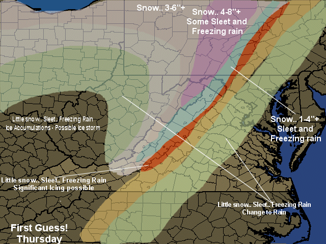
2/11 FIRST GUESS POSTED

In general, this looks like a serious storm, but most of Virginia and NC will be spared the winter threat. Snow to start in the DC area and down to Carlottesville, followed by a serious Ice threat. N and W of DC and in Western Maryland and north, a serious snow threat.
 
Map can be found on the website!
 
OF NOTE: Latest model runs seem to imply less snow and more icing or even rain threat! Realize this is a Guess at this point!
 
Will TRY and get a new map out early tomorrow. MAY not be able to provide anything other than analysis beyont that until tomorrow night! By that time, the storm will be on the doorstep!
 
The Forum has been active with 11 new members this weekend. A Pro meteorologist is also posting some thoughts! feel free to join in on the thoughts!
 
All for now!
 
Mid Atlantic Weather: http://www.midatlanticweather.com
Mid Atlantic Weather Forum: http://www.midatlanticweather.com/bb3


Have a burning question? Go to Yahoo! Answers and get answers from real people who know.

Saturday, February 10, 2007

2/11 HEAVY WINTER STORM TUESDAY


HEAVY SNOW STORM WITH POSSIBLE ICING

Things are lining up for a major Winter Storm. Especially  north of Fredericksburg . Areas could see up to a foot and some places more especially in Maryland. MANY factors could change who get the biggest snows and even ice storm possibilities. Best Chances seem to be Washington, DC to Charlottesville and north as well as up to Baltimore and North. Ice could really become an issue in the transition area.

This one is a serious one. Please stay tuned to radio and news outlets.

More to come!


Mid Atlantic Weather: http://www.midatlanticweather.com
Mid Atlantic Weather Forum: http://www.midatlanticweather.com/bb3


Get your own web address.
Have a HUGE year through Yahoo! Small Business.

Friday, February 09, 2007

LARGE WINTER STORM LIKELY!

Areas may see 10 - 20 inches. Please stay tuned!

Saturday, January 20, 2007

Winter Weather Alert

Snow will Visit Region with 1-3" and mixes as well.

1-3" will fall from a n area north Charlottesville to Fredericksburg line and South of a Frederick county to Baltimore county line. Then a mix will occur from Richmond Southwest to the areas just east of the North Carolina Mountains. It would appear that .10 to .25" of ice is possible, the heaviest in Valleys and areas just east of the Mountains (Up to 40 miles east of Mountains in the Piedmont.)

This is not a huge event, but ice would be an issue for travel. Precip will start later in the morning in the SW and late in the day for the northern parts.

Snow will end as freezing drizzle. Of note, when these storms are ideal some places get some heavier precip so isolated 4-5" totals on snow would not surprise me!

Later next week, POTENTIAL, Really is there for a good snow for parts of the region! I will keep you posted. No time to do a map tonight, MAY have one tomorrow Morning!!!!

Thursday, January 18, 2007

Winter Weather Alert


Light accumulations of a Mixture of Precip

Light Snow, Sleet, and Rain and Freezing Rain will all visit the Regions, but mainly the North Carolina and Southern Virginia regions. The mixture could cause some icing troubles, especially this morning in North Carlina and Southern Virginia as only a small coating of ice could cause havoc. Please stay alert and tuned in to Local News and Radio outlets for updates on your regions weather.

There is a possibility of a more significant storm on Sunday Night and again North Carolina and Southern Virginia could be the more problematic spots based on current model read out. This could significantly change between now and Sunday Evening.

Stay Alert!

All for now!

Mid Atlantic Weather: http://www.midatlanticweather.com
Mid Atlantic Weather Forum: http://www.midatlanticweather.com/bb3


Don't be flakey. Get Yahoo! Mail for Mobile and
always stay connected to friends.

Friday, February 10, 2006

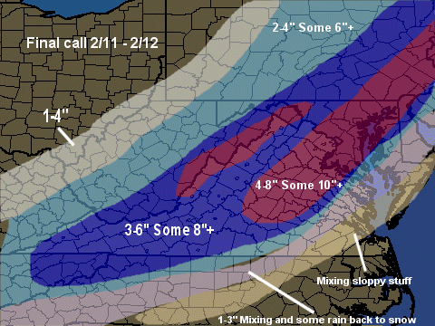
2/11 - 2/12 final call


My Thoughts:
Hagerstown: 4-8”
Frederick, MD: 4-8”
Montgomery, MD: 5-9”
Baltimore: 6-10” D.C: 6-10” (Maybe some sleet/rain at start)
Dulles: 4-8” (Maybe some sleet)
Fredericksburg: 6-10” (Maybe some sleet)
Salisbury: 1-3” then Rain
Richmond: 3-6” (Mixing with rain and sleet)
Williamsburg 1-3” (Mixing with sleet and rain)
Emporia: Mix then rainVA Beach: Rain (Sorry stormy! )
Martinsburg: 3-6” (Some Sleet)
Roanoke: 3-6”
Charlottesville: 4-8”
Leesburg: 4-8”

Tuesday, December 13, 2005

12/15 First Call


What?
Significant Icing event. Moderate Icing event and Light Icing event
Some Accumulating Snows

Where?
Significant Icing: Immediate Piedmont: Maryland, Virginia, North Carolina
Major Icing: Immediate Piedmont to 35 miles west of I-95; Maryland, Virginia
North Carolina : West Central NC
Light Icing: I-95 to about 35 miles west of I-95: West Central NC
Snows: Higher elevations of Northern Virginia and Western Maryland. A large Part of Pennsylvania, West 40 miles west of I-95

When? Starting Thursday Early Morning South overspreading northern areas by Late Morning

Comments: Tough call in many ways. A lot of precip will fall over very shallow cold air. The Warm air appears to truly Surge over the area and warm areas close to or above freezing. There is a chance for significant rains as well. If things stay frozen, ice storm conditions could be reached by a lot more areas than what I am indicating on my first guess map. May issue a follow up call tomorrow night.. but my guess may be all the time I have to do.

http://mawinterweather.blogspot.com

Of Note: Large potential Snow Storm early next week!