Sunday, December 04, 2005

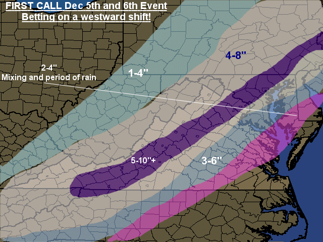
12/5 - 12/6 First CALL

Ok. This is my first call, likely final call after next Model runs.Giving some Locations and amounts!
Charlottesville: 5-10" Starting Early Afternoon
Roanoke: 5-10"+ (Some spots 12") Starting 7-9am
Lynchburg 4-8" Starting 7-9am
Richmond: 3-6" Starting 9am - noon
Fredericksburg: 5-10" Starting noon to 3pm
DC National: 5-10" Starting 3-6pm
Baltimore: 5-10" Startng 5-8pm
IAD: 5-10" Starting 3-6pm
Hagerstown: 4-8" Starting 3-6pm
Purcellville: 4-8" Starting 3-6pm

Few things on this:
1. Think Storm will be further west
2. See good Wrap around/deformation zone possible
3. Expecting a closer to the coast pull ultimately

Saturday, December 03, 2005

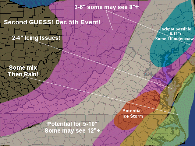
Second Guess Dec 5th/6th event!


I am betting on a pretty big blockbuster here! Only concern would be track.. but I think plenty of dynamics get involved and push it high and precip far west!

Final call will be issued Tomorrow later afternoon or evening. Sorry, busy day will preclude sooner. May send updates if things change dramatically!

12/3 Winter Weather Alert! For TONIGHT's storm

 
Second storm looking like a classic I-95 Storm now!


Great School in Northern Virginia. http://www.ambleside.org


Yahoo! DSL Something to write home about. Just $16.99/mo. or less

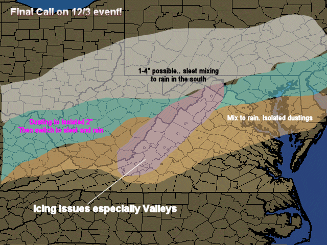
Final Call 12/3 Event

I am concerned about the Valleys seeing an Ice Storm. Expect Winter Storm Warnings for some Far western Counties.

Storm for Monday is becoming a CLASSIC winter Storm.. I-95 cities could be very white. Will post updates on this later this evening!

Friday, December 02, 2005

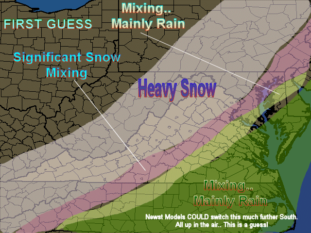
First Guess! 12/5 Event


MAY REALLY SHIFT! Stand By!

First Real Snow Chances for the Region Monday. Appetizer tomorrow Night.

First Real Snow Chances for the Region Monday. Appetizer tomorrow Night.
 
What? 2 Systems will affect the region between Today and Tuesday with Winter weather
 
System 1: No big deal, but a burst of snow and sleet should occur tomorrow evening that should last until Midnight.
 
System 2: Significant chance of a real snowstorm.
 
Where?
System 1: Northern 2/3rds of Virginia and Western Maryland. The Snow should change to rain for most regions, but North Central Maryland and the Northwestern part of Virginia.
 
System 2: All regions could see some snow, but again, best chances appear to be northern 2/3rds of Virginia, and western 2/3rds of Maryland. Snow should overtake the region and then a mix to rain, very quickly southern regions, and slowly a creep northward and westward. Right now would call for I-95 areas north of Frederickburg to see a moderate event, while areas west of this by 15 to 20 miles will see a potentially major storm.
 
How Much?
System 1: Dusting most areas at best, but 1 to as much as 3 inches in the areas staying snow or a mix. Grassy and elevated surfaces only.
 
System 2: (First Guess here) Potential exists for the Moderate areas to see 3 to 5 inches and the Major areas (mainly snow) to see 5 to 10 inches with some 12 inch readings in the higher elevations and immediate piedmont areas of Northern Virginia (North of Charlottesville and  western Maryland).
 
When?
System 1: Saturday late day through Midnight for most regions, but the areas mentioned where accumulations could occur will be through Sunday Morning.
 
System 2: Sunday Night through Monday.. possibly stretching to early Tuesday morning.
 
Comments: System 1 will not be a big deal. System 2 seriously could be, but we are early in the game on this! Shifts in the track obviously mean chances for more or less snow. As models converge on the system, updates will come. Also of note, roads are warm so salt will do a good job on helping melt the snow.
 
Expect snow impact Maps possibly tonight or tomorrow morning.. First Guess on Accumulations afternoon or evening tomorrow.
 
All for Now!

Yahoo! Shopping
Find Great Deals on Gifts at Yahoo! Shopping

Saturday, November 12, 2005

11/12 2005-2006 Winter Outlook

2005-2006 Winter Outlook
 
I will make this more formal soon!
 
I am on board with a normal to slightly above normal winter. However, the SST's off the east coast and in the Gulf I think will (and have already proven to do so) aid to very moist storms up the East Coast. With that in mind, in the brief colder snaps (I think most will last for about a week.if not briefer. like we have seen) I see very energetic storms forming with abilities for Severe weather in the Southeast and also strong Nor'easters. So, if cold enough, the storms that do occur should have great potential for large amounts of precip and of course Snow! So, snow should be above normal in the Piedmont and interior Upper Mid Atlantic (VA, MD, PA, NJ) and New england, with coastal plains dealing with a lot of turnover or mix scenarios.. not surprising, as strong storms should throw warm air off the oceans inland.. and with warmer sea temps, this does not look good for areas east of I-95 in the Mid Atlantic in general.
Restating: Brief cold snaps and large storms.. a few storms should make above normal snow piedmont and higher elevations of the Mid Atlantic, and also in interior New England. Normal to slightly above normal temperatures overall.
Factors considered:
Slow Snow cover expansion in Canada (Just a trend I am watching)
Cold pool off Pacific NW Coast (Not good)
Warmer waters (at least for now) off East (Strengthens East Coast Storms)
Weather trends seen this fall. (Drought buster and Tropical systems)
ENSO.. Not a factor this year
Not a big analog person as I have seen this hurt some forecasts dramatically! (Last year comes to mind)
And yes.. the watch of other meteorologist's predictions. (Helps confirm or challenge my thinking)
 
That is it. I will make it more fromal soon!


Yahoo! FareChase - Search multiple travel sites in one click.

Wednesday, March 09, 2005

untitled

It is becoming increasingly possible that a period of wet snow will end the rain that occurs overnight. Amounts, and whether or not anything will accumulate are not clear at this time. This may just be a period of snow with little or no accumulations, but I felt it would be prudent to alert people to the possibilities since there is a chance some accumulations could occur from this event.


Areas most at risk for accumulations are the I-95 corridor and east up to just inland from the coast.


If accumulations appear likely a more important alert will be issued!


Enjoy the warmth today!


This outlook was brought to you by A Cleaner Carpet Co! Check out what makes their carpet cleaning, cleaner than others!
http://www.acleanercarpetco.com (Oriental Rug Cleaning also available) (703) 772 - 5157

The best telecommunication options you could ever need! http://www.tellifone.com.. yeah, I know I misspelled it!

Monday, March 07, 2005

3/7 Some Snow Alert

It is becoming increasingly possible that a period of wet snow will end the rain that occurs overnight. Amounts, and whether or not anything will accumulate are not clear at this time. This may just be a period of snow with little or no accumulations, but I felt it would be prudent to alert people to the possibilities since there is a chance some accumulations could occur from this event.


Areas most at risk for accumulations are the I-95 corridor and east up to just inland from the coast.


If accumulations appear likely a more important alert will be issued!


Enjoy the warmth today!


This outlook was brought to you by A Cleaner Carpet Co! Check out what makes their carpet cleaning, cleaner than others!
http://www.acleanercarpetco.com (Oriental Rug Cleaning also available) (703) 772 - 5157

The best telecommunication options you could ever need! http://www.tellifone.com.. yeah, I know I misspelled it!

Sunday, February 27, 2005

12/28 Final Call

Big Winter Storm Commencing!

What?

Major Winter Storm

When?

From Tonight Through Late Tuesday Night, though bulk will fall next 24 hours

How Much?

I have my final call map here: http://www.midatlanticweather.com/images/2_28_2005_F.gif

Some Locations:

Hagerstown: 8-10

Dulles: 8-10

Washington DC: 6-8

Fairfax: 8-10

Charlottesville: 8-10

Lynchburg: 4-6 some Freezing Rain

Roanoke: 8-10

Wytheville: 8-10

Danville: 1-3 Freezing Rain Threat

Richmond: 1-3 To Rain

Fredericksburg: 4-6

NOTE: These could be underdone! There will be Thundersnows tomorrow and I could really be
under doing the amounts! I am playing it safe with eth QPF from models Also, the area expecting a large mix.. if it is snow.. that will be much higher!

Concerns:

1.
Models suddenly warmer and less precip. Is this true? Doubt it looking at Radar.

2.
Really, my concern is that the precip totals could be too low!

3.
May see a regeneration of snow again tomorrow night as the Upper level system comes through


4.
Winds will start to be an issue tomorrow night… This could mean we get to Blizzard Conditions? That will need toe be assessed tomorrow and more likely north of our region of the country

5.
Far western VA and Maryland (western facing slopes)could see a serious amount of snow tomorrow night into Tuesday from wrap around and that upper level disturbance.

All for now.

Please join the forum and give your updates on the storm!http://www.midatlanticweather.com/bb/


Friday, February 25, 2005

2/25 BIG Storm Monday Could Bring BIG SNOW!

Big Storm Monday likely to start as Snow for areas central and west and may stay that way west of I-95, especially higher elevations!
 
I will do a full update later tonight or early tomorrow morning! Mountains, get ready! West of I-95 for the Northern half of the area! Stay alert!
 
If, by chance, things line up, there could be locally 1 to 2 feet of snow in areas! The higher your elevation, the more concerned you need to be!
 
More to come!
 
All for Now!


This outlook was brought to you by A Cleaner Carpet Co! Check out what makes their carpet cleaning, cleaner than others!
http://www.acleanercarpetco.com (Oriental Rug Cleaning also available) (703) 772 - 5157

The best telecommunication options you could ever need! http://www.tellifone.com.. yeah, I know I misspelled it!

__________________________________________________
Do You Yahoo!?
Tired of spam? Yahoo! Mail has the best spam protection around
http://mail.yahoo.com

Wednesday, February 23, 2005

2/24 DC/MD/VA SNow Final Call

Snow Alert Final Call


What: moderate to potentially heavy Snow event.


Where: Today we had a major Shift North. Southern VA likely to see rain. Northern Virginia and Maryland will see Moderate to heavy accumulations

Final Calls for some select locations.

Dulles – 4-8

DC – 3-6

Baltimore - 4-8

Hagerstown - 6-10

Charlottesville – 3-6

Orange – 3-6

Fredericksburg – 3-6

Spotsylvania – 3-6

Ashland – 1-3

Richmond – 1-3

Roanoke – 1-3

Lynchburg - 2-4

See Map: http://www.midatlanticweather.com/Images/2_24_2005_f.gif

When: Starting: 2 am Southwest. Overspreading the north by 9 am. Expecting heavier snow between 10 am and 3 pm .. may see a lull and then a regeneration of light snow tomorrow evening and night in the North.

Concerns:

1.
Limiting factor may be the convection to our south

2.
Mix may make it to DC suburbs south of town

3.
Could see cold air wrap into system and give some snow back to south central regions

4. Snow deformation line/wrap around possible Central Maryland into Northern Virginia


2/24 Second Guess:Note Shift North

Note the shift to the North. This may not be done.


Tuesday, February 22, 2005

First Guess

2/22 DC/MD/VA Snow Alert for Thursday

Snow Alert


What?: Moderate Snow Event

Where? Most of Virginia and Maryland

When? Thursday

How Much?

2-4 Northern Virginia and Maryland areas

4-8 Central Virginia

2-4 NC/VA Border with Sleet and Freezing rain involved especially coast!

Could see heavier amounts of 10 inches in parts of the region!


Accumulations vary North to south and not east to west in this event. (Further north the less the amounts)


Concerns:

  1. Northern cut off of precip could be sharp so Northern Maryland could see far less
  2. Higher Ratios could up the Northern Virginia and Maryland amounts.
  3. Precip could come further north than what models show.. but not by much!
  4. Low may not come far enough north (low risk, but there)


OF NOTE: Cold air is not a big issue with this event as the last 2 events, thus snowfall much more likely in this event


Hope for Snowfall maps later tonight!


This outlook was brought to you by A Cleaner Carpet Co! Check out what makes their carpet cleaning, cleaner than others!
http://www.acleanercarpetco.com (Oriental Rug Cleaning also available) (703) 772 - 5157

The best telecommunication options you could ever need! http://www.tellifone.com.. yeah, I know I misspelled it!


Do you Yahoo!?
Yahoo! Search presents - Jib Jab's 'Second Term'

2/22 DC/MD/VA Snow Alert

Snow Alert


What?: Moderate Snow Event

Where? Most of Virginia and Maryland

When? Thursday

How Much?

2-4 Northern Virginia and Maryland areas

4-8 Central Virginia

2-4 NC/VA Border with Sleet and Freezing rain involved especially coast!

Could see heavier amounts of 10 inches in parts of the region!

Accumulations vary North to south and not east to west in this event. (Further north the less the amounts)


Concerns:


  1. Northern cut off of precip could be sharp so Northern Maryland could see far less

  2. Higher Ratios could up the Northern Virginia and Maryland amounts.

  3. Precip could come further north than what models show.. but not by much!

  4. Low may not come far enough north (low risk, but there)


OF NOTE: Cold air is not a big issue with this event as the last 2 events, thus snowfall much more likely in this event

Hope for Snowfall maps later tonight!


Saturday, February 19, 2005

2/20 Snow Alert

Snow Event Diminished

What: Light Snow Possible
Where: Northern VA and Central MD Immediate Piedmont to areas just east of I-95
When: Sunday afternoon through Monday Morning
How Much: At most, I could sonly see a 1-3” snow based on models. Areas really DC to Dulles To Baltimore and north have the greatest threat of accumulations with higher amounts north. Isolated 4” near the PA/MD border would not surprise me. See http://www.midatlanticweather.com/2_22_2005_f.gif
Concerns: It appears warmth will really work fast to erode cold air. I will continue to monitor. Seems really cold, but strong southerly winds are at play here so a quick turnover would not surprise me!

Snow/Wintry Event More Likely

What: Light to Moderate Snow
Where: Northern VA and Central MD Immediate Piedmont to areas just east of I-95
When: Sunday afternoon through Monday Morning
How Much: Refer to http://www.midatlanticweather.com/2_20_2005_.gif looks like 2-4” immediate Piedmont North of Charlottesville up through Maryland. 1-3” I-95 areas Fredericksburg and north.
Concerns: I hope I am not overdoing precip. Still could have to shift this north if warmer air is more powerful.


Friday, February 18, 2005

2/18 DC/MD/VA WInter Weather Alert

Winter Weather Alert. Possible storm..

What: Looks more likely that a Small to moderate snow will affect parts of the region.

Where: the Northern areas of Virginia and Maryland especially piedmont areas

How Much: A general 1-4 inch snowfall is possible with some amounts to 6+ inches in the far Northern VA and the immediate piedmont of Maryland. A changeover to light sleet and freezing rain is possible near the end of the storm with plain rain further South and East, and eventually a cold drizzle or light rain most places by Monday Afternoon.


When:
Starting Sunday Afternoon and ending Monday Morning.

Why will this happen, why might it not:

Models are really split on the scenario and this split brings a wide range of solutions. Best bet is a start as a mix of snow and rain to mainly snow northern areas. A quick turnover to rain any outhern areas and a slower turnover north. The idea is that the warm air will not overwhelm the storm before a coastal locks colder air in for northern areas. The coastal is a big factor in this forecast and it may not form. Consistently one model has shown a much warmer pattern and another a colder. Which one is right? If we compromise, I would say not a big storm for many. That is why my range is so large. 1 to 4 inches in the north. I have to say a possible 6 inch plus because if the colder model wins a more significant system could affect the region. One other note, precip amounts on the colder model has been very wrong with storm totals in this region this winter usually favoring more precip than less. I was burned in January and then again the next storm. I have to be more conservative this time. This is my first guess too!

More to come.


Wednesday, February 02, 2005

02/02 Southwestern Virginia Snow Alert!

Southwestern Virginia Snow Alert!

Between Tonight and Friday Morning, as Much as 8” of snow could fall in the Higher elevations of Southwestern Virginia. Areas specifically west of Lynchburg to Martinsville and east of Bristol and Bluefield. Even at lower elevations as much as 3-6” of snow is possible.

There is also the possibility of mixed rain and snow and some sleet as far north as a Harrisonburg to Frederickburg to Salisbury. Areas south of this line will have periods of Rain and snow mixed (especially at night). Southern Virginia, especially areas close to the above mentioned area of Southwestern Virginia, could see some light accumulations of 1 to 3 inches.

This situation could change and move precipitation more northward or even southward. Models continue to track the systems poorly. Also, cold air is not in great abundance, so whereas the higher elevations of Southwestern Virginia seem Likely to get good snows, lower elevations could mix and be primarily rain at times. This scenario is not easy to predict.
All for now!